0818 66 33 33
24/7 Emergency Nationwide


Topographical & GIS Mapping Services for Commercial Projects
We specialise in high-quality topographical surveys and GIS mapping services for businesses across Ireland, providing precise and actionable insights.

20+ Years
Experience

Nationwide
Coverage

3 Hour
Emergency Response

Fully Licensed
& Insured
MCBREEN ENVIRONMENTAL
What is Topographical Surveying & GIS Mapping?
A topographical survey is a detailed representation of the land’s natural and man-made features, including contours, elevations, water bodies, buildings, and infrastructure. By integrating GIS mapping, we can spatially analyse and visualise data, which is essential for projects that require precise planning, environmental assessments, and infrastructure development.
Topographical Surveys: Include the collection of data on the physical features of the land, such as slopes, vegetation, and roads.
GIS Mapping: Utilises geospatial data and advanced software to create digital maps that support data analysis and decision-making for complex projects.

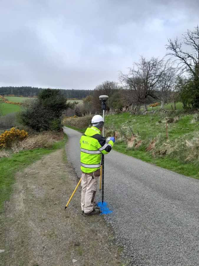

Advanced Technology for Precise Data Collection
McBreen Environmental uses cutting-edge technologies to collect accurate data for your topographical and GIS mapping needs:
Drone Survey: Our UAVs (unmanned aerial vehicles) capture high-resolution images of your underground assets.
Laser Scanning: We use advanced laser scanning technology to capture highly accurate measurements of both large-scale and complex sites.
GPS Systems: We employ high-precision GPS units to gather exact coordinates for mapping, ensuring minimal error in your surveys.

COMMERCIAL SERVICES
Our Commercial Services

.webp)


Why Choose McBreen Environmental?
Expertise: Our surveyors are experienced professionals who have conducted topographical surveys for a range of industries, including construction, engineering, and environmental consulting.
State-of-the-Art Equipment: We utilise the latest drone technology, laser scanning, and GPS systems to ensure the highest levels of accuracy and precision.
Environmental Responsibility: Our surveys assist in environmental assessments, ensuring projects meet all environmental regulations and minimise ecological impact.
Customised Solutions: We tailor our services to meet the specific requirements of your project, whether it's land development, infrastructure design, or environmental consulting.

IRELAND NATIONWIDE SERVICES
Service Areas Across Ireland
McBreen Environmental provides topographical surveying and GIS mapping services across Ireland, including Dublin, Cork, Galway, Louth, Roscommon, and Cavan. We ensure that your project receives the highest-quality data, wherever you are located.
Frequently Asked Questions
What is the difference between topographical surveys and GIS mapping?
A topographical survey focuses on gathering physical data about land features such as contours, vegetation, and structures. GIS mapping involves spatial analysis, using geospatial data to create digital maps and models for further analysis and decision-making.
How accurate are your topographical surveys?
We use the latest technology, including GPS, laser scanning, and drone surveying, to ensure our surveys are highly accurate, with minimal margin for error.
What industries do you serve with your topographical surveys?
We serve a wide range of industries, including land development, urban planning, construction, engineering, and environmental consulting.
How long does it take to complete a topographical survey?
The timeline for completing a survey depends on the size and complexity of the site. We provide an estimated completion date after assessing your project requirements.
Can GIS mapping be used for environmental assessments?
Yes, GIS mapping is an invaluable tool for environmental assessments, helping identify sensitive areas and ensuring that projects comply with environmental regulations.